
$49.95
CD: Valuation Maps, Toledo Subdivision
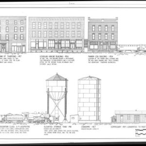
The Toledo Subdivision CD has 151 maps. It has all the maps from when the Hocking Valley was valued, and updated maps as they were needed into the modern C&O Era. As might be expected there is much on Columbus and Parsons, etc.
The Valuation map originals are about 24×56 inches each, and they cover from a mile (for terminals, etc.) to several miles (mainlines), and show all tracks, sidings, location of railroad owned buildings, road crossings, towers, etc. They are a superb source for historical and operational data and modelers should love them as sources for layout design. Each CD has all these large maps digitized so that they will appear on your screen in high resolution up to 400% magnification, making them highly useable.
CD: Valuation Maps, Toledo Subdivision
The Toledo Subdivision CD has 151 maps. It has all the maps from when the Hocking Valley was valued, and updated maps as they were needed into the modern C&O Era. As might be expected there is much on Columbus and Parsons, etc.
The Valuation map originals are about 24×56 inches each, and they cover from a mile (for terminals, etc.) to several miles (mainlines), and show all tracks, sidings, location of railroad owned buildings, road crossings, towers, etc. They are a superb source for historical and operational data and modelers should love them as sources for layout design. Each CD has all these large maps digitized so that they will appear on your screen in high resolution up to 400% magnification, making them highly useable.


Reviews
There are no reviews yet.